![]() By Jerilyn Ritzman, WSU Extension Island County Shore Stewards Program Coordinator.
By Jerilyn Ritzman, WSU Extension Island County Shore Stewards Program Coordinator.
How Puget Sound Builds its Beaches
Introduction
Our beaches often feel like a constant but, whether during a harsh winter storm or a calm summer day, they are constantly changing and have developed over a rather small portion of our geologic timeline. If you’re like me, you spend a lot of time marveling at the steep bluffs, the variety of rocks and wildlife, but it isn’t often that we stop to think about all of nature’s processes that created and maintain these beaches. So, let’s take a few moments to appreciate what goes into making and sustaining our beaches, and what we can do to help keep them healthy.
Source of beach sediment
 Left by the ice
The recent history of our region’s beaches begins with the last ice age glaciation, known as the Vashon Glaciation, roughly 20,000 to 15,000 years ago. It began when a massive ice sheet began advancing southward from present-day British Columbia through the Puget Lowland. At its maximum extent around 17,000 years ago, this ice sheet extended to just south of Olympia and was estimated to be about a mile thick at the U.S.-Canada border. Though the glacier was thinner further south, it was still about 3,000 feet thick (the height of five Space Needles!) near Seattle. After around 100 years at its maximum, the ice sheet retreated northward over twice as fast as it advanced, leaving the Puget Sound largely the way it appears today.
The glacier deposited large amounts of sediment across the Puget Lowland during its advance and retreat. As the ice advanced southward through British Columbia, it eroded and entrapped rocks ranging in size from silt and sand to gravel and even boulders. As the glacier continued through the Puget Sound and eventually started its retreat, several depositional processes occurred.
First, as the glacier approached, it significantly altered the streams in its vicinity. Existing streams became dammed by the ice, creating “pro-glacial” lakes where fine clay particles accumulated. Meltwater from the glacier also created its own streams, which carried away the mix of sediments (called outwash) that were trapped in the ice. In a process known as “sorting”, larger rocks settled out of these meltwater streams closer to the glacier, while smaller particles were carried farther away, sometimes also into the pro-glacial lakes.
Together, the ice damming and outwash sorting processes left distinct sediment layers as the glacier approached, with a unit of clay (the Lawton Clay) deposited first and then a unit of sand (the Esperance Sand) deposited above it.
Next, when the glacier covered an area, melting along the bottom of the ice caused entrapped material to fall to ground level, where it was quickly compacted by the overlying ice. This dense, cement-like layer of unsorted sediment of all different sizes is known as glacial till. The Vashon Glaciation’s is known specifically as the Vashon Till and, where it is present, it overlies the Esperance Sand. Finally, as the glacier retreated, a loose layer of outwash sediment was left on top.
These layers, along with similar sequences from previous glaciations, are the primary strata you will find along the edges of river valleys and coastal bluffs in the Puget Lowland. Glacial deposits thus provide much of the raw material that makes up our beaches today, often with sediment from as far away as British Columbia. It can be fascinating to pick up just a single rock and imagine its journey of hundreds of miles and thousands of years, made possible by immense geologic forces.
Dropped by feeder bluffs
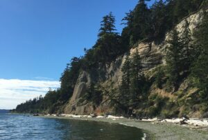
Coastal bluffs form some of the most dramatic shorelines in our region. They are found along approximately 60% of Puget Sound’s shorelines and can rise up to 400 feet high. Their erosion provides sediment directly to our beaches. Bluffs that supply significant amounts of sediment are sometimes known as “feeder bluffs”.
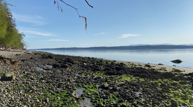
Beaches below bluffs tend to be narrow and made of a mix of coarser sediments—sand and gravel. This is the result of the erosion and sorting of many sediment layers exposed along the bluff face. Among other forces, wave action at the toe (bottom) of the bluff slowly undermines the upper layers, causing them to collapse either bit-by-bit or in the occasional landslide. The waves again play a major role in sorting the mix of sediment on the beach, carrying off the finest-grained particles and leaving the beach narrower and coarser. Storms can exacerbate both wave action and landslides, accelerating bluff erosion and sediment delivery to beaches.
Landslides, and bluff erosion in general, are understandably concerning to many shoreline residents. In the past, this has often been addressed by the installation of hard shoreline armoring: structures such as bulkheads that are intended to shield the beach or prop up the bluff. About a third of Puget Sound’s shorelines currently have some sort of armoring. While hard armor can prevent erosion in the short term, it can often end up causing problems of its own or even increasing erosion in the long term by cutting off the natural flow of sediment that replenishes the beach. While each beach may require unique management techniques, it is important to remember that erosion is a natural process that generally occurs slowly. Natural bluff erosion rates in the Puget Sound are typically on the order of a few centimeters landward per year. Taking this into account in any long-term plan for bluff properties will help avoid the need for costly armoring projects and their associated disruptions to natural beach-building processes.
Brought by the rivers
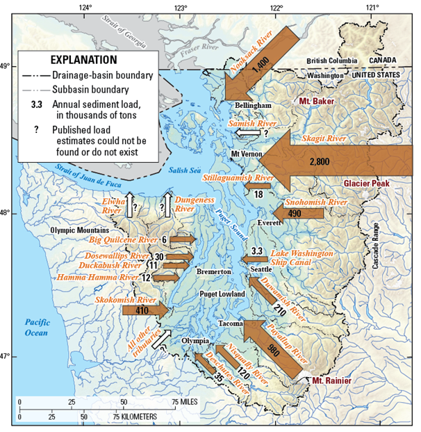
Along the shore of Puget Sound, much of the sediment not derived from bluffs can be traced back to rivers originating in the Cascade and Olympic Mountains. Collectively, these rivers deliver an estimated 6.5 million tons of sediment to Puget Sound each year. However, this sediment goes through a much different journey to reach the beach, and therefore has different characteristics than bluff sediment.
At high elevations, glacial meltwater and landslides deliver a mix of sediment to streams as they begin their journeys downhill. The steep topography in turn creates high energy, fast-flowing streams that are capable of scouring additional sediment from their banks and carrying larger rocks downstream. Think of the waterfalls and rapids you often see in mountainous regions. As rivers wind their way out of the mountains, they begin to take on a gentler profile and slower speed, which causes the larger sediment grains to “settle out” of the water and rest on the riverbed. Human infrastructure on the river, such as dams, can also impound large amounts of sediment. By the time most rivers have reached the Puget Sound, their sediment load is primarily sand and silt, different than the wider mix of rock sizes typically found at bluff-backed beaches.
Once rivers meet the Puget Sound, they typically discharge the fine sediment in a wide delta, another difference from the narrower, bluff-backed beaches. Deltas, especially for the largest rivers, are complex environments driven by the interaction between freshwater and saltwater processes. A single delta may contain many different habitat types, such as salt marshes and muddy tidal flats, depending on local conditions and proximity to the beach. While the character of river deltas can differ significantly from bluff-backed beaches, both provide sediments that can then be transported laterally to other beaches.
Carried by the waves
Shoreline evolution doesn’t stop when sediment reaches the beach. Winds and waves continue shifting the sediment up, down, and sideways along the beach, either maintaining a beach’s structure or transforming it. One process that can take place is the transport of sediment sideways along the beach, usually in a consistent direction. This is referred to as littoral drift or longshore drift (or simply shore drift) and a stretch of beach with a consistent transport direction is referred to as a drift cell. In the Puget Sound, the predominant wind direction is from the southwest, so many drift cells flow in whichever direction is closest to northeast. Seasonal changes and local conditions that influence wave direction can create drift cells that flow in other directions.
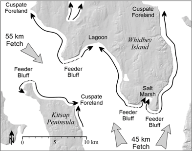
Distinct landforms often form at the ends of drift cells where sediment is deposited. These are influenced by many factors, including the characteristics of the existing beach, the arrangement of the drift cell(s), and the amount and type of sediment being transported. For example, where a single drift cell terminates, sand can accumulate in a spit that extends out into the water, growing longer each year. Where two drift cells converge, they can form a sharp, triangular landform called a cuspate foreland, or can create a barrier beach around a lagoon or other protected embayment. While these processes can be slow and difficult to see, a beach that appears to be unchanging might only persist if it is continually replenished by its drift cell. If the original sediment sources, such as feeder bluffs or river deposits, are cut off, then the beaches receiving those sediments might shrink or change in structure. A shoreline modification (e.g., installation of hard armoring) made at a single beach can thus impact many other beaches that are part of its drift cell.
Why beaches matter
Once established, healthy, functioning beaches provide numerous ecosystem services, including shelter from storms, substrate for aquatic plants to grow, and recreational opportunities for humans. To illustrate the many interconnected services a beach provides, we will focus on just one example: forage fish spawning habitat.
Forage fish are a group of small schooling fishes that provide a critical link in the marine food web, providing food for animals such as sea birds, marine mammals, and economically important salmon like Chinook and Coho. Juvenile salmon especially depend on forage fish as they transition from eating smaller prey such as insects and prepare to migrate out to the Pacific Ocean. Of the six species of forage fish in Puget Sound, three in particular—surf smelt, sand lance, and Pacific herring—rely on the nearshore environment for spawning.
Surf smelt and sand lance both lay their eggs during high tide in the upper intertidal zone of sand and gravel beaches. A variety of beaches in Puget Sound could serve as spawning habitat, but certain parts of drift cells tend to be most frequently used due to their favorable sediment grain sizes. Surf smelt spawning is common in the middle portion of bluff-derived drift cells because sediment tends to be too coarse directly under feeder bluffs and too fine at the drift cell’s terminus. On the other hand, the even finer sand preferred by sand lance is common in the accretionary shoreforms such as spits at the terminus of drift cells. Disruptions to feeder bluffs or their drift cells can alter these sediment regimes, often making them coarser, and can prevent these forage fish from spawning there.
Pacific herring lay their eggs lower in the beach profile, in the lower intertidal and shallow subtidal range, primarily on marine vegetation such as eelgrass. Eelgrass habitat is also primarily found in sand and gravel, which again can be disrupted by changes in sediment delivery to beaches or drift cell processes.
Reduction in forage fish spawning habitat is just one of many potential consequences of human alteration of the shoreline. It is important that we recognize that many species depend on healthy, functioning beaches, and that our beaches in turn depend on a variety of complex processes to be replenished. Understanding the sediment that builds our beaches can also help us make decisions for the long-term care of shoreline properties, ensuring that our beaches will be around for all to enjoy.
Resources
Past editions of Shore Stewards News have addressed some of these topics. These and other newsletters are available at WSU Extension Island County Shore Stewards’ newsletter archive.
For a fascinating close-up look at the glacial deposits in a Puget Sound bluff, check out this YouTube video by Nick Zentner from Central Washington University.
Shore Friendly has created some beautiful animations of drift cells in section 3 of this web page. See how one of the longest drift cells in the Puget Sound is right here in Island County! Shore Friendly has also started a video series on YouTube about Puget Sound’s shorelines, and the first video highlights coastal beaches and bluffs.
The Washington State Dept. of Ecology has developed a number of maps to explore Puget Sound’s shorelines.
Some highlights include:
- Puget Sound Nearshore Map: Want to know which drift cell your beach belongs to, or whether your bluff is classified as a feeder bluff? This map can tell you a lot about your beach.
- Feeder Bluffs and Coastal Landforms: This “story map” pairs explanations of different shoreline types with photos of example locations around Puget Sound.
- Shoreline Photo Viewer: Get a bird’s-eye view of any beach in Washington State! You can also choose from a selection of time series going back to 1976.
- Washington State Coastal Atlas: Choose from a selection of pre-made shoreline maps, or create your own custom map using many of the data layers in the maps mentioned above.
Bibliography
Curran, Christopher A., Eric E. Grossman, Mark C. Mastin, and Raegan L. Huffman. 2016. “Sediment load and distribution in the lower Skagit River, Skagit County, Washington.” United States Geological Survey (USGS) Scientific Investigations Report 2016-5106, 24p. https://doi.org/10.3133/sir20165106.
Czuba, Jonathan A., Christopher S. Magirl, Christiana R. Czuba, Eric E. Grossman, Christopher A. Curran, Andrew S. Gendaszek, and Richard S. Dinicola. 2011. “Sediment load from major rivers into Puget Sound and its adjacent waters.” United States Geological Survey (USGS) Fact Sheet 2011-3083, 4p. https://doi.org/10.3133/fs20113083.
Czuba, Jonathan A., Christopher S. Magirl, Christiana R. Czuba, Christopher A. Curran, Kenneth H. Johnson, Theresa D. Olsen, Halley K. Kimball, and Casey C. Gish. 2012. “Geomorphic analysis of the river response to sedimentation downstream of Mount Rainier, Washington.” United States Geological Survey (USGS) Open-File Report 2012-1242, 134p. https://doi.org/10.3133/ofr20121242.
Dawes, Ralph L., and Cheryl D. Dawes. 2013. “Geology of the Pacific Northwest – Virtual Field Site – Discovery Park | PNW Geology Virtual Field Sites.” Wenatchee Valley College, Department of Geology. Last modified July 17, 2013. https://commons.wvc.edu/rdawes/virtualfieldsites/DiscoveryPark/VFSDscvryPk.html.
Dethier, Megan N., Jason D. Toft, and Hugh Shipman. 2016. “Shoreline Armoring in an Inland Sea: Science‐Based Recommendations for Policy Implementation.” Conservation Letters 10 (5): 626–633. https://doi.org/10.1111/conl.12323.
Dunagan, Christopher. 2016. “Sources of sand: maps show crucial ‘feeder bluffs’.” Encyclopedia of Puget Sound, April 7, 2016. https://www.eopugetsound.org/magazine/armoring-bluffs.
Finlayson, David, and Hugh Shipman. 2003. “Puget Sound drift cells—The importance of waves and wave climate.” Puget Sound Notes 47: 1–4.
Hicock, Stephen R., and John E. Armstrong. 1985. “Vashon Drift: definition of the formation in the Georgia Depression, southwest British Columbia.” Canadian Journal of Earth Sciences 22 (5): 748–757. https://doi.org/10.1139/e85-079.
Johannessen, Jim, and Andrea MacLennan. 2007. Beaches and Bluffs of Puget Sound. Puget Sound Nearshore Partnership Report No. 2007-04. Published by Seattle District, U.S. Army Corps of Engineers, Seattle, Washington. https://wdfw.wa.gov/publications/02216.
Kelly, Doug. 2021. “Understanding Groundwater Science with Doug Kelly.” PowerPoint presentation. Presented virtually February 6, 2021 at Sound Waters University, hosted by Sound Water Stewards. Recording is password-protected. https://vimeo.com/510846043.
Mullineaux, Donal Ray, Howard Hamilton Waldron, and Meyer Rubin. 1965. “Stratigraphy and chronology of late interglacial and early Vashon glacial time in the Seattle area, Washington.” United States Geological Survey (USGS) Bulletin 1194-O, 15p. https://doi.org/10.3133/b1194O.
Parks, David, Anne Shaffer, and Dwight Barry. 2013. “Nearshore Drift-Cell Sediment Processes and Ecological Function for Forage Fish: Implications for Ecological Restoration of Impaired Pacific Northwest Marine Ecosystems.” Journal of Coastal Research 29 (4): 984–997. https://doi.org/10.2112/JCOASTRES-D-12-00264.1.
Penttila, Dan. 2007. Marine Forage Fishes in Puget Sound. Puget Sound Nearshore Partnership Report No. 2007-03. Published by Seattle District, U.S. Army Corps of Engineers, Seattle, Washington. https://wdfw.wa.gov/publications/02193.
Porter, Stephen C., and Terry W. Swanson. 1998. “Radiocarbon Age Constraints on Rates of Advance and Retreat of the Puget Lobe of the Cordilleran Ice Sheet during the Last Glaciation.” Quaternary Research 50 (3): Article QR982004: 205–213. https://doi.org/10.1006/qres.1998.2004.
Quinn, Timothy, Kirk Krueger, Ken Pierce, Daniel Penttila, Kurt Perry, Tiffany Hicks, and Dayv Lowry. 2006. “Patterns of Surf Smelt, Hypomesus pretiosus, Intertidal Spawning Habitat Use in Puget Sound, Washington State.” Estuaries and Coasts 35 (5): 1214–1228. https://doi.org/10.1007/s12237-012-9511-1.
Rhodes, Linda. 2019. “The Marine Nearshore: Interface between Land and Sea.” PowerPoint presentation. Presented in person November 4, 2019 for Washington State University (WSU) Extension, Island County. Recording is public. https://youtu.be/9-z-uPjuGY0.
Savage, William Z., Meghan M. Morrissey, and Rex L. Baum. 2000. “Geotechnical properties for landslide-prone Seattle; area glacial deposits.” United States Geological Survey (USGS) Open-File Report 2000-228, 5p. https://doi.org/10.3133/ofr00228.
Shipman, Hugh. 2004. “Coastal bluffs and sea cliffs on Puget Sound, Washington.” https://apps.ecology.wa.gov/publications/documents/0406029.pdf. In Formation, Evolution, and Stability of Coastal Cliffs – Status and Trends, edited by Monty A. Hampton and Gary B. Griggs, 81–94. United States Geological Survey (USGS) Professional Paper 1693, 123p. https://doi.org/10.3133/pp1693.
Shipman, Hugh. 2008. A Geomorphic Classification of Puget Sound Nearshore Landforms. Puget Sound Nearshore Partnership Report No. 2008-01. Published by Seattle District, U.S. Army Corps of Engineers, Seattle, Washington. https://wdfw.wa.gov/publications/02190.
Shipman, Hugh. 2010. “The geomorphic setting of Puget Sound: implications for shoreline erosion and the impacts of erosion control structures.” https://pubs.usgs.gov/sir/2010/5254/pdf/sir20105254_chap2.pdf. In Puget Sound shorelines and the impacts of armoring—proceedings of a state of the science workshop, May 2009, edited by Hugh Shipman, Megan N. Dethier, Guy R. Gelfenbaum, Kurt L. Fresh, and Richard S. Dinicola, 19–34. United States Geological Survey (USGS) Scientific Investigations Report 2010-5254, 262p. https://doi.org/10.3133/sir20105254.
Shipman, Hugh, Andrea MacLennan, and Jim Johannessen. 2014. “Puget Sound Feeder Bluffs: Coastal erosion as a sediment source and its implications for shoreline management.” Shorelands and Environmental Assistance Program, Washington Department of Ecology, Olympia, WA. Publication #14-06-016. https://apps.ecology.wa.gov/publications/SummaryPages/1406016.html.
Shore Friendly. n.d. “Hard Armor, Bulkheads, & Seawalls – Shore Friendly.” Accessed April 13, 2021. http://www.shorefriendly.org/your-options/hard-armor/.
Shore Friendly. n.d. “Puget Sound in the Balance: Your Property and the Big Picture | Shoreline Ecosystem | Shore Friendly.” Accessed April 13, 2021. http://www.shorefriendly.org/shoreline-ecosystem/.
Sound Science Contributors, NOAA Fisheries, Northwest Fisheries Science Center. 2007. “Section 3.4.2: Shoreline Formation and Sediment-Transport Processes.” In Sound Science: Synthesizing ecological and socioeconomic information about the Puget Sound ecosystem, coordinated by Mary H. Ruckelshaus and Michelle M. McClure, 19–21. Prepared in cooperation with the Sound Science collaborative team. U.S. Dept. of Commerce, National Oceanic & Atmospheric Administration (NMFS), Northwest Fisheries Science Center. Seattle, Washington. 93p. Full text available at the Puget Sound Institute Blog: http://www.pugetsoundinstitute.org/wp-content/uploads/2011/12/SoundScience2007.pdf. Section 3.4.2 accessed via dedicated re-post “Shoreline formation in Puget Sound.” Encyclopedia of Puget Sound, February 16, 2012. https://www.eopugetsound.org/articles/shoreline-formation-puget-sound.
Swanson, Terry W. 2009. “Late Pleistocene Glacial History of Whidbey Island, WA”. Field trip handbook. University of Washington, Department of Earth and Space Sciences, 23p. http://faculty.washington.edu/tswanson/302add/Field%20Trips/Trip2009.pdf.
Williams, David B. 2001. “What Lies Beneath.” Columns, April 2001. Published by the University of Washington Alumni Association. Page 3 of 5. https://www.washington.edu/alumni/columns/june01/earthquake3.html.
(WA DNR) Washington State Department of Natural Resources. n.d. “Moraines | Glacial Features | Puget Lowland | WA – DNR.” Accessed April 13, 2021. https://www.dnr.wa.gov/programs-and-services/geology/explore-popular-geology/geologic-provinces-washington/puget-lowland#glacial-features.2.
(WA DNR) Washington State Department of Natural Resources. n.d. “Puget Sound Geology | Puget Sound and Coastal Geology | WA – DNR.” Accessed April 13, 2021. https://www.dnr.wa.gov/programs-and-services/geology/explore-popular-geology/puget-sound-and-coastal-geology#puget-sound-geology.
![]()
Thank you for reading Shore Stewards News.
Shore Stewards, Washington State University, Pullman, WA
Accessibility | Copyright | Policies
WSU Extension programs and employment are available to all without discrimination. Evidence of noncompliance may be reported through your local WSU Extension office.